Works with one boat
Forecast
Wind, gusts, seas, freezing spray and sea ice along your own grounds, hour by hour. It is built from the 2.5 km Environment and Climate Change Canada (ECCC) model, not one number for a whole marine area.
Fleet weather for commercial harvesters
FleetCast gives each boat a 2.5 km forecast for its own grounds, then checks it against what the boats report and shares it across a fleet you trust. Built for the coast of Labrador and the harvesters who work it.
Live on a demo fleet with real Environment and Climate Change Canada forecast data.
Works with one boat
Wind, gusts, seas, freezing spray and sea ice along your own grounds, hour by hour. It is built from the 2.5 km Environment and Climate Change Canada (ECCC) model, not one number for a whole marine area.
Coming next
The skipper’s phone will supply position and motion, plus one tap condition reports. On the demo fleet today, those reports are simulated. A marine sensor kit follows, to log true wind, pressure and sea state every minute.
Grows with every boat
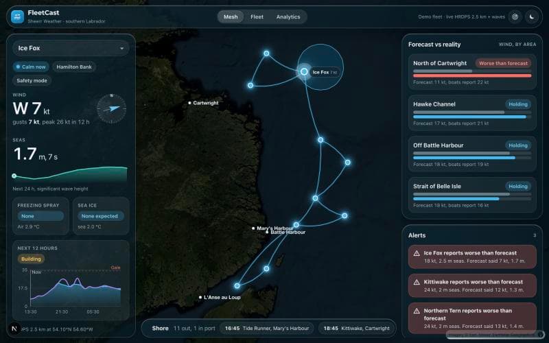
Every boat is a node on a live map, linked to its neighbours. You see what the boats ahead are reporting, and a running score of forecast against reality, area by area.
These are screens from the working app, running on a demo fleet with invented boat names and the live ECCC forecast.
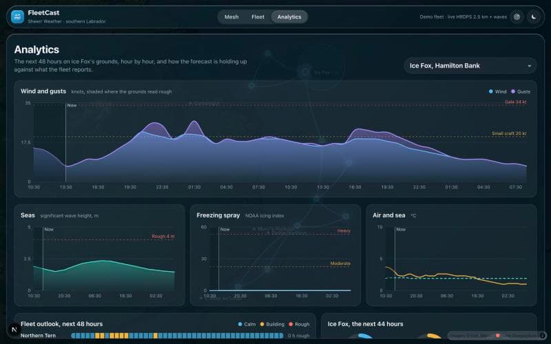
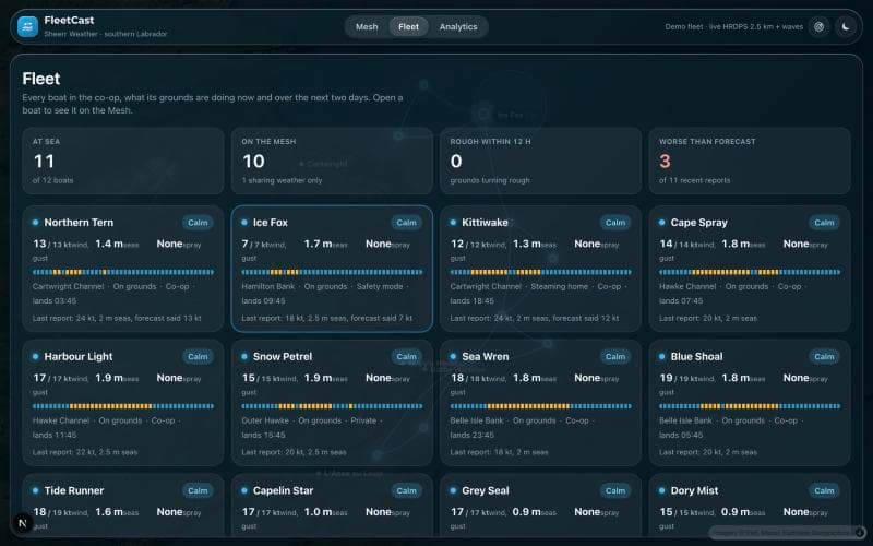
Demo fleet. Boat names and positions are invented.
Off Labrador there are very few buoys and stations, so nobody knows where the forecast is wrong. The boats do. FleetCast compares what the forecast said with what the fleet reports, area by area. On the demo fleet the boat reports are simulated.
Wind by area, knots
Forecast 11 kt, boats report 22 kt
Forecast 17 kt, boats report 21 kt
Forecast 18 kt, boats report 19 kt
Example shown with demo boats.
One purchase puts a whole fleet on the map, inside a group that already trusts each other.
See which boats are out, which are in port and when each is expected to land, so the plant can schedule with more than a guess.
Conditions flow between the boats in your group. Nobody outside it sees your positions.
A running log of forecast against reality that shows where the models struggle on your coast.
Software first. The phone is the sensor. Hardware comes when you want more.
Available now on a demo fleet
The forecast for your grounds, the Mesh, forecast against reality, alerts, the AI crew briefing and the shore dashboard.
Planned
The skipper app will send position, motion and one tap condition reports from the phone already on board. Not built yet.
Planned
A marine weather station measuring true wind, pressure, air temperature and sea state every minute, plus a Starlink Mini for boats without a data link. Not built yet.
FleetCast is decision support that sits next to the official ECCC marine forecast and the VHF weather broadcast. It does not replace them. The skipper makes every call.
What your boat records belongs to you. Anything beyond your own fleet is shared only with your consent.
Choose to share your exact position inside your fleet, share more widely as a safety mode, or stay private.
Tell us about your fleet or plant and we will set up a walk through. This opens an email to us; nothing is sent until you press send.